Trail Walking La Forteresse - Croix de Baron - Photo
© OpenStreetMap contributors
Length
Length
9.6 km
Max alt
Max alt
750 m
Uphill gradient
Uphill gradient
274 m
Km-Effort
Km-Effort  
13.2 km
Min alt
Min alt
532 m
Downhill gradient
Downhill gradient
274 m
Boucle
Boucle
Yes
Creation date :
2017-11-27 00:00:00.0
Updated on :
2017-11-27 00:00:00.0

(2 Reviews)

Walking
Walking
3h15
Difficulty : Medium

Scan this QR Code to open this trail in the SityTrail application

FREE GPS app for hiking

Logo SityTrail SityTrail

IGN / Geographical institutes

Download SityTrail from the App Store Download SityTrail from Google Play

Logo SityTrail SityTrail World

The world is yours!

Download SityTrail from the App Store Download SityTrail from Google Play Download SityTrail on Huawei AppGallery

About

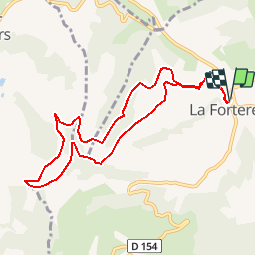
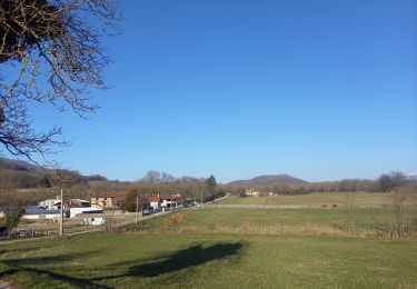
Trail Walking of 9.6 km to be discovered at Auvergne-Rhône-Alpes, Isère, La Forteresse. This trail is proposed by raymondfn.

Description

Parking à l'entrée de La Forterese.
Circuit : Le Château, Valette, la Combe Profonde, les Arêtes, la Croix de Baron, Montolivet, Les Bruyères, le Four, Revolet, Chapon
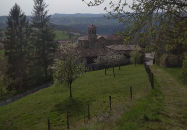
Parcours sans difficulté sur chemins et petites routes dans les collines, parmi noyers, prés et petits bois.
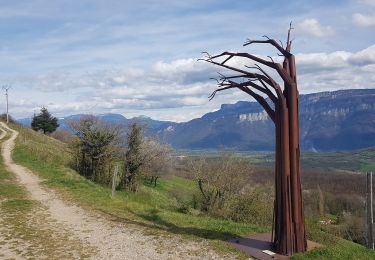
Beaux points de vue en particulier dans la descente vers Montolivet.

Elevation profile

Positioning

Country:
France
Region :
Auvergne-Rhône-Alpes
Department/Province :
Isère
Municipality :
La Forteresse
Location:
Unknown
Start:(UTM)
688353 ; 5018623 (31T) N.

Comments

Please log in to post a review or rate the element


Belle petite rando....avec vue sur le Mont Blanc ! Merci !


Circuit sympa, Chemins larges, à faire en famille, bien aussi pour le VTT


Trails nearby

Trail Walking Vatilieu - Les Crêtes de Vatilieu - Photo
Walking
patjobou

Walking

Medium
Vatilieu, Auvergne-Rhône-Alpes, Isère, France
11.5 km | 17.6 km-effort
3h 31min
Yes
Trail Walking Vatilieu - 38 vatilieu - Photo
Walking
himba26100

Walking

Easy
Vatilieu, Auvergne-Rhône-Alpes, Isère, France
11.4 km | 17.4 km-effort
6h 22min
Yes
Trail Walking Serre-Nerpol - toutes aures - Photo
Walking
ALAIN3859

Walking

Easy
Serre-Nerpol, Auvergne-Rhône-Alpes, Isère, France
4 km | 6.5 km-effort
2h 5min
No
Trail Walking Saint-Michel-de-Saint-Geoirs - SaintMichel-Les Arêtes - Photo
Walking
raymondfn

Walking

Medium
(1)
Saint-Michel-de-Saint-Geoirs, Auvergne-Rhône-Alpes, Isère, France
8.9 km | 13.1 km-effort
1h 47min
Yes
Trail Walking Vatilieu - vatillieu  - Photo
Walking
bpc

Walking

Medium
Vatilieu, Auvergne-Rhône-Alpes, Isère, France
12.1 km | 18.1 km-effort
3h 33min
Yes
Trail Walking La Forteresse - Autour de LA FORTERESSE  - Photo
Walking
Marco Paulo

Walking

Easy
La Forteresse, Auvergne-Rhône-Alpes, Isère, France
16.7 km | 24 km-effort
4h 30min
Yes
Trail Walking Brion - Col de Toutes Aures-Varacieux-Vinay-Notre Dame de l'Osier-Vatillieu - Photo
Walking
Jean-Alain Vorgeat

Walking

Very difficult
Brion, Auvergne-Rhône-Alpes, Isère, France
42 km | 58 km-effort
8h 29min
Yes
Trail Walking La Forteresse - foyer rural La Forteresse - Photo
Walking
lilloue

Walking

Difficult
La Forteresse, Auvergne-Rhône-Alpes, Isère, France
8.2 km | 13.2 km-effort
2h 57min
Yes
Trail Walking Cras - Etang de Tullins - Photo
Walking
crocau

Walking

Easy
(1)
Cras, Auvergne-Rhône-Alpes, Isère, France
3.2 km | 4 km-effort
45min
No


Close
My subscriptions